1993 No. 850
The Calderdale and Kirklees (Metropolitan Borough Boundaries) Order 1993
Made
Laid before Parliament
Coming into force
for the purposes referred to in article 1(2)
for all other purposes
The Secretary of State, in exercise of his powers under sections 51(2) and 67(4) of the Local Government Act 19721 and of all other powers enabling him in that behalf, hereby makes the following Order which gives effect to proposals submitted to him under sections 47, 48(1) and 51(1) of that Act, more than six weeks before the making of this Order by the Local Government Boundary Commission for England:
Citation and commencement1
1
This Order may be cited as the Calderdale and Kirklees (Metropolitan Borough Boundaries) Order 1993.
2
This Order shall come into force on 1st December 1993 for any purpose set out in regulation 4(1) of the Local Government Area Changes Regulations 19762.
3
For all other purposes, this Order shall come into force on 1st April 1994.
Interpretation2
In this Order—
“Calderdale” means the West Yorkshire metropolitan borough of Calderdale, and “Kirklees” means the West Yorkshire metropolitan borough of Kirklees;
“map” means one of the 6 maps prepared by the Department of the Environment, marked “Maps of the Calderdale and Kirklees (Metropolitan Borough Boundaries) Order 1993”, duly numbered for reference, and deposited in accordance with regulation 5 of the Local Government Area Changes Regulations 1976; and
“ward” means a ward of the metropolitan borough from or to which an area is transferred by this Order, except in the expression “parish ward”, where it means a ward of the parish to which an area is transferred.
Transfers from Calderdale to Kirklees3
Each area which is marked as indicated in column 1 of the following Table on the map shown in column 2 shall be transferred from Calderdale, and from the ward named in column 3 to—
a
Kirklees; and to
b
the ward and petty sessional division named in column 4.
(1) | (2) | (3) | (4) |
|---|---|---|---|
Area marked | On map | Transferred from Calderdale, and and from the following ward— | To Kirklees, and to— |
B9 | 2 | Brighouse | Cleckheaton ward Batley and Dewsbury petty sessional division |
B10 | 3 | Brighouse | Spen ward Batley and Dewsbury petty sessional division |
B5 | 1 | Elland | Birkby ward Huddersfield petty sessional division |
B4 | 1 | Elland | Lindley ward Huddersfield petty sessional division |
B17 | 5 | Greetland and Stainland | Colne Valley West ward Huddersfield petty sessional division |
B1 B11 B 12, B14 & B16 | 1 4 6 | Greetland and Stainland | Lindley ward Huddersfield petty sessional division |
B8 | 2 | Hipperholme and Lightcliffe | Cleckheaton ward Batley and Dewsbury petty sessional division |
6 | 1 | Rastrick | Birkby ward Huddersfield petty sessional division |
B7 | 1 | Rastrick | Deighton ward Huddersfield petty sessional division |
Transfers from Kirklees to Calderdale4
Each area which is described in column 1 of the following Table shall be transferred from Kirklees to—
a
Calderdale;
b
the ward (and the parish and parish ward, if any) named in column 2; and to
c
the Calderdale petty sessional division.
Area of Kirklees transferred— | To Calderdale, and to— |
|---|---|
The parts of the Colne Valley West ward marked C1 and C2 on map 5. | Parish of Ripponden Barkisland parish ward Ryburn ward |
The part of the Lindley ward marked on B3 on map 1. | Elland ward |
The parts of the Lindley ward marked B2 on map 1, B18 on map 5, and B13 and B15 on map 6 | Greetland andStainland ward |
Town and Country Planning5
1
In this article, “provision” means a provision of a development plan (as defined in section 336(1) of the Town and Country Planning Act 19903).
2
Any provision applying to an area transferred by this Order shall continue to apply to that area, notwithstanding the transfer, until replaced by a provision which so applies, and which is expressed to supersede the preserved provision.
Signed by authority of the Secretary of State for the Environment
(This note is not part of the Order)
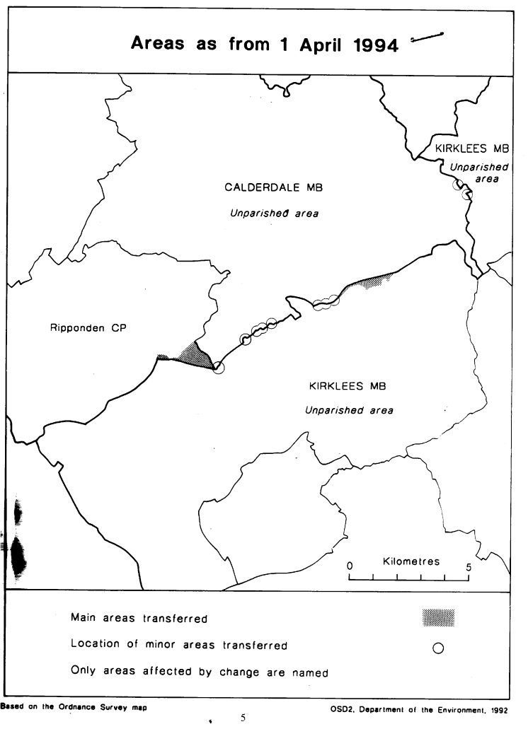
This Order transfers small areas between the metropolitan boroughs of Calderdale and Kirklees in West Yorkshire.
Consequential changes are made to wards of those boroughs and to the boundaries of petty sessional divisions.
The map and list forming part of this note (page 5) give a general guide to the changes made.
Prints of the detailed order maps (described in article 2) may be inspected at all reasonable times at the offices of the council for each metropolitan borough affected, and also at the offices of the Secretary of State for the Environment located in 2, Marsham Street, London SW1P 3EB.
In approximate terms, the land transferred from Calderdale to Kirklees has a total area of 70 hectares, and a population of 110, and that transferred from Kirklees to Calderdale a total area of 120 hectares, and a population of 67.
The Local Government Area Changes Regulations 1976 (S. I. 1976/246, amended by S. I. 1978/247) contain general provisions regarding the effect of orders such as this one.
LIST SUMMARISING CHANGES EFFECTED
1
At Upper Firth House Mills, boundary is realigned to the north side of the M62 carriageway, uniting the Mills in Calderdale.
2
At Scammonden, an area of land south of the M62 motorway and to the north west of Royal Ings is transferred to Kirklees.
3
At Glenden Works, Outlane, there is a minor realignment of boundary to unite the Works in Kirklees.
4
At Burcote Drive, Outlane, there are minor realignments to unite the Drive in Kirklees.
5
At Gees Garage, Outlane, there is a realignment to place the whole of the Garage in Kirklees.
6
Lee Hill Farm, Outlane, is transferred to Calderdale, and the boundary realigned to place the whole of the nearby motorway intersection in Kirklees.
7
Minor realignments are made at Ainley Top along the A643 road.
8
Realignments to follow northern line of the M62 in vicinity of Cote Lane, Clough Lane and Toothill Lane South.
9
At Windy Bank Farm, Hartshead, a realignment to unite the Farm in Kirklees.
10
At Highmoor Lane, Hartshead Moor, a realignment to unite No. s 65 and 67 in Kirklees.