- Latest available (Revised)
- Original (As made)
The Bus Lane Contraventions (Approved Local Authorities) (England) (Amendment) and Civil Enforcement of Parking Contraventions Designation Order 2012
You are here:
- UK Statutory Instruments
- 2012 No. 846
- Whole Instrument
- Previous
- Next
More Resources
Status:
This is the original version (as it was originally made). This item of legislation is currently only available in its original format.
Statutory Instruments
2012 No. 846
Local Government, England
Road Traffic, England
The Bus Lane Contraventions (Approved Local Authorities) (England) (Amendment) and Civil Enforcement of Parking Contraventions Designation Order 2012
Made
21st March 2012
Laid before Parliament
23rd March 2012
Coming into force
Articles 1 to 3, and 5
16th April 2012
Article 4
11th June 2012
This Order is made in exercise of powers conferred by—
(a)section 89(3) of the Traffic Management Act 2004(1) (“the 2004 Act”);
(b)paragraph 8(1) of Schedule 8 to the 2004 Act;
(c)paragraph 3(1) of Schedule 10 to the 2004 Act; and
(d)section 144(3)(b) of the Transport Act 2000(2).
The Derby City Council(3) has applied to the Secretary of State for an order to be made, in exercise of the powers mentioned at paragraphs (b) and (c) above, in respect of part of that council’s area.
The Hampshire County Council has applied to the Secretary of State for an order to be made, in exercise of the powers mentioned at paragraphs (b) and (c) above, in respect of part of that council’s area.
The Northumberland County Council(4) has applied to the Secretary of State for an order to be made, in exercise of the powers at paragraphs (b) and (c) above, in respect of part of that council’s area.
The Solihull Metropolitan Borough Council(5) has applied to the Secretary of State for an order to be made, in exercise of the powers mentioned at paragraphs (b) and (c) above, in respect of part of that council’s area.
The Somerset County Council has applied to the Secretary of State for an order to be made, in exercise of the powers mentioned at paragraphs (b) and (c) above, in respect of part of that council’s area.
In accordance with the requirements of paragraph 8(3) of Schedule 8, and paragraph 3(4) of Schedule 10, to the 2004 Act, the Secretary of State has consulted the chief officers of police of Derbyshire Constabulary, Hampshire Constabulary, Northumbria Police, West Midlands Police and Avon and Somerset Police.
Accordingly, the Secretary of State(6) makes this Order.
Citation and commencement
1.—(1) This Order may be cited as the Bus Lane Contraventions (Approved Local Authorities) (England) (Amendment) and Civil Enforcement of Parking Contraventions Designation Order 2012.
(2) Except for article 4, this Order comes into force on 16th April 2012.
(3) Article 4 comes into force on 11th June 2012.
Revocation of previous orders
2. The Road Traffic (Permitted Parking Area and Special Parking Area) (City of Derby) Order 2006(7) and the Road Traffic (Permitted Parking Area and Special Parking Area) (Metropolitan Borough of Solihull) Order 2007(8) are revoked.
Designation of civil enforcement areas and special enforcement areas under the Traffic Management Act 2004
3.—(1) The Secretary of State designates each of the areas mentioned in paragraph (2) as—
(a)a civil enforcement area for parking contraventions; and
(b)a special enforcement area.
(2) The areas are—
(a)the part of the area of The Derby City Council specified in Schedule 1;
(b)the part of the area of The Hampshire County Council specified in Schedules 2 and 3;
(c)the part of the area of The Northumberland County Council specified in Schedule 4; and
(d)the part of the area of The Solihull Metropolitan Borough Council specified in Schedule 5.
4. The Secretary of State designates the part of the area of The Somerset County Council specified in Schedule 6 as—
(a)a civil enforcement area for parking contraventions; and
(b)a special enforcement area.
Amendment of the Bus Lane Contraventions (Approved Local Authorities) (England) Order 2005
5.—(1) The Bus Lane Contraventions (Approved Local Authorities) (England) Order 2005(9) is amended as follows.
(2) In the table in Schedule 2, after the row relating to The North Lincolnshire Borough Council, insert—
| “The Northumberland County Council | 2012/846” |
Signed by the authority of the Secretary of State
Norman Baker
Parliamentary Under Secretary of State
Department for Transport
21st March 2012
SCHEDULES
Article 3(2)(a)
SCHEDULE 1The part of the area of The Derby City Council designated as a civil enforcement area for parking contraventions and as a special enforcement area
The whole of the area of The Derby City Council except—
(a)the entire length of the A38 within the city, including its on and off slip roads and all roundabouts;
(b)the A52 from the pentagon roundabout to the eastern city boundary including all its on and off slip roads except Wyvern Way;
(c)the A5111 from its junction with the A6005 to its transition to the A6 at Ordnance Survey national grid reference point SK3875533861, including its on and off slip roads;
(d)the A6, Alvaston Bypass, from its transition to the A5111 at Ordnance Survey national grid reference point SK3875533861 to the city boundary, including its on and off slip roads;
(e)the Etwall Road/Ladybank Road roundabout, Mickleover, including the eastbound slip road to the A516;
(f)the entire length of the A50 within the city including its on and off slip roads; and
(g)the A516 from its junction with the A38 to the western city boundary, including its on and off slip roads.
Article 3(2)(b)
SCHEDULE 2The part of the area of The Hampshire County Council designated as a civil enforcement area for parking contraventions and as a special enforcement area
The whole of the area of The East Hampshire District Council except—
(a)the A3 road from the boundary with The Surrey County Council at Bramshott Chase at Ordnance Survey national grid reference point SU8721933970 to its transition to the A3(M) motorway at Catherington at Ordnance Survey national grid reference point SU7053114081, including its slip roads;
(b)the A3 spur road from its roundabout junction with the A272 and the B2070 at Ordnance Survey national grid reference point SU7563024168 to its junction with the mainline of the A3 road at Warren Copse at Ordnance Survey national grid reference point SU7514924941, including its slip roads;
(c)the A3(M) motorway from its transition to the A3 road at Catherington at Ordnance Survey national grid reference point SU7053114081 to the boundary with The Havant Borough Council at Blendworth Common at Ordnance Survey national grid reference point SU7051211138, including its slip roads; and
(d)the following roads in Bordon, in each case illustrated generally by the outer edge of a black line forming the boundary of a hatched area in a Map in Schedule 3—
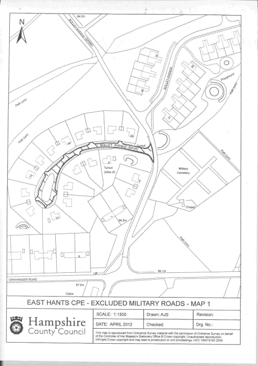
(i)the Bolley Avenue spur from its junction with the Bolley Avenue spine at Ordnance Survey national grid reference point SU7872936259 to the end of the cul-de-sac at Ordnance Survey national grid reference point SU7859436184 as illustrated in Map 1 in Schedule 3;
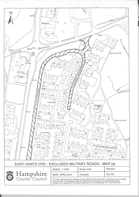
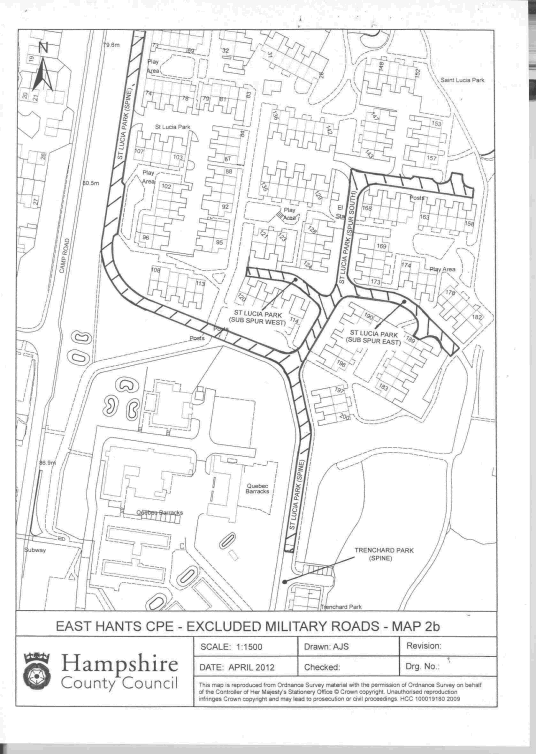
(ii)the Saint Lucia Park spine from its junction with Lindford Road at Ordnance Survey national grid reference point SU8006036540 to its transition to the Trenchard Park spine at Ordnance Survey national grid reference point SU8003336044 as illustrated in Maps 2a and 2b in Schedule 3;
(iii)the Saint Lucia Park spur north from its junction with the spine at Ordnance Survey national grid reference point SU8005236504 to the end of the cul-de-sac at Ordnance Survey national grid reference point SU8002036369 as illustrated in Map 2a in Schedule 3;
(iv)the Saint Lucia Park spur south from its junction with the spine at Ordnance Survey national grid reference point SU8003636163 to the end of the cul-de-sac at Ordnance Survey national grid reference point SU8014736270 as illustrated in Map 2b in Schedule 3;
(v)the Saint Lucia Park sub spur east from its junction with the spur south at Ordnance Survey national grid reference point SU8006936210 to the end of the cul-de-sac at Ordnance Survey national grid reference point SU8013636170 as illustrated in Map 2b in Schedule 3;
(vi)the Saint Lucia Park sub spur west from its junction with the spur south at Ordnance Survey national grid reference point SU8005636198 to the end of the cul-de-sac at Ordnance Survey national grid reference point SU8000836220 as illustrated in Map 2b in Schedule 3;
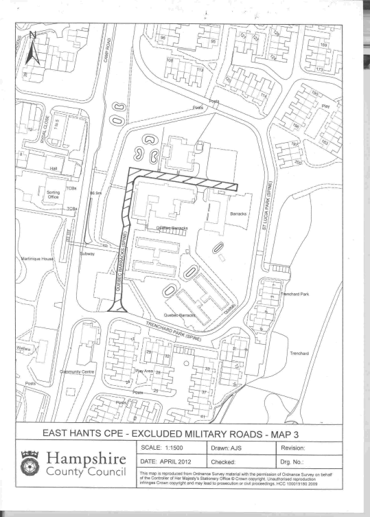
(vii)the Quebec Barracks spine from its junction with the Trenchard Park spine at Ordnance Survey national grid reference point SU7990435990 to the end of the cul-de-sac at Ordnance Survey national grid reference point SU8001236105 as illustrated in Map 3 in Schedule 3;
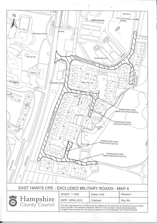
(viii)the Trenchard Park spine from its junction with the A325 Camp Road at Ordnance Survey national grid reference point SU7986535988 to its transition to the Saint Lucia Park spine at Ordnance Survey national grid reference point SU8003336044 as illustrated in Map 4 in Schedule 3;
(ix)the Trenchard Park spur from its junction with the spine at Ordnance Survey national grid reference point SU7989135982 to the end of the cul-de-sac at Ordnance Survey national grid reference point SU7982835768 as illustrated in Map 4 in Schedule 3;
(x)the Trenchard Park main sub spur south from its junction with the spur at Ordnance Survey national grid reference point SU7983735780 to the end of the cul-de-sac at Ordnance Survey national grid reference point SU7995035764 as illustrated in Map 4 in Schedule 3;
(xi)the subsidiary Trenchard Park sub spur south from its junction with the main sub spur south at Ordnance Survey national grid reference point SU7988435772 to the end of the cul-de-sac at Ordnance Survey national grid reference point SU7989035810 as illustrated in Map 4 in Schedule 3;
(xii)the Trenchard Park main sub spur north from its junction with the spur at Ordnance Survey national grid reference point SU7988735920 to the end of the cul-de-sac at Ordnance Survey national grid reference point SU7995535908 as illustrated in Map 4 in Schedule 3;
(xiii)the subsidiary Trenchard Park sub spur north from its junction with the main sub spur north at Ordnance Survey national grid reference point SU7994835904 to the end of the cul-de-sac at Ordnance Survey national grid reference point SU7993635860 as illustrated in Map 4 in Schedule 3;
(xiv)the Trenchard Park spur east from its junction with the spine at Ordnance Survey national grid reference point SU8001435980 to the end of the cul-de-sac at Ordnance Survey national grid reference point SU8002535932 as illustrated in Map 4 in Schedule 3;
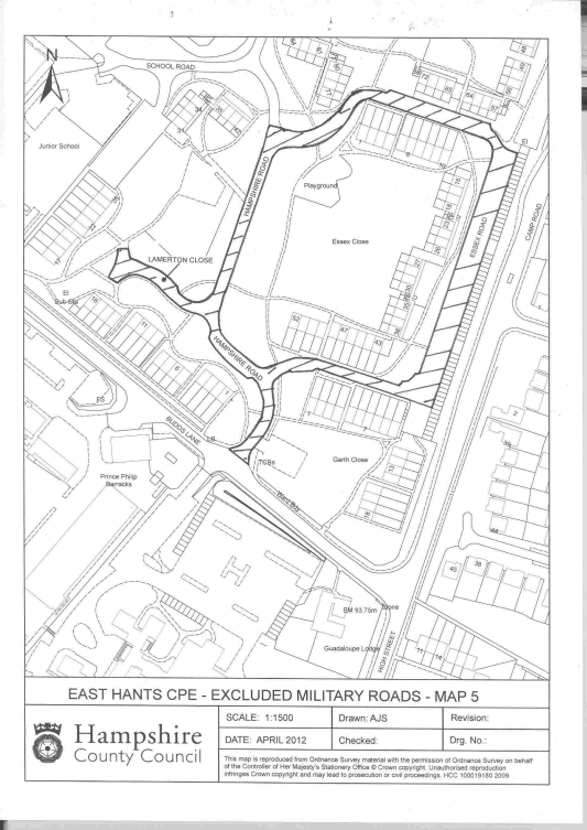
(xv)Hampshire Road from its junction with Budds Lane at Ordnance Survey national grid reference point SU7963635632 to its junction with Essex Road at Ordnance Survey national grid reference point SU7965635815 as illustrated in Map 5 in Schedule 3;
(xvi)Lamerton Close from its junction with Hampshire Road at Ordnance Survey national grid reference point SU7961935715 to the end of the cul-de-sac at Ordnance Survey national grid reference point SU7956635740 as illustrated in Map 5 in Schedule 3; and
(xvii)Essex Road from its northern junction with Hampshire Road at Ordnance Survey national grid reference point SU7965635815 to its southern junction with Hampshire Road at Ordnance Survey national grid reference point SU7965335677 as illustrated in Map 5 in Schedule 3.
Article 3(2)(b)
SCHEDULE 3Map 1
Map 2a
Map 2b
Map 3
Map 4
Map 5
Article 3(2)(c)
SCHEDULE 4The part of the area of The Northumberland County Council designated as a civil enforcement area for parking contraventions and as a special enforcement area
The whole of the area of The Northumberland County Council except—
(a)the A1 road from the boundary with The North Tyneside Metropolitan Borough Council at Seaton Burn interchange at Ordnance Survey national grid reference point NZ2325674531 to the border with Scotland at Ordnance Survey national grid reference point NT9739557054 including its slip roads;
(b)the A19 road from the boundary with The North Tyneside Metropolitan Borough Council immediately east of the Fisher Lane roundabout at Ordnance Survey national grid reference point NZ2369174610 to the further boundary with The North Tyneside Metropolitan Borough Council at Ordnance Survey national grid reference point NZ2821973424 including its slip roads;
(c)the A69 road from the boundary with The Cumbria County Council at Temon Bridge at Ordnance Survey national grid reference point NY6172963902 to the border with The Council of the City of Newcastle Upon Tyne at Ordnance Survey national grid reference point NZ1456667735 including its slip roads;
(d)the A189 road from the boundary with The North Tyneside Metropolitan Borough Council at Annitsford at Ordnance Survey national grid reference point NZ2714773648 to the northern side of Woodhorn Roundabout, Ashington, at Ordnance Survey national grid reference point NZ2945488283 including its slip roads;
(e)the U4023 road from a point immediately west of Alwinton village at Ordnance Survey national grid reference point NT9064606515 to the Makendon Cattle Grid at Ordnance Survey national grid reference point NT8030909338;
(f)the U5001 road from its junction with the A68 road at Ordnance Survey national grid reference point NY8270998219 to Redesdale Camp at Ordnance Survey national grid reference point NY8283198396;
(g)the U5003 road from a point north of its junction with the A68 road at Ordnance Survey national grid reference point NY8559596763 to Toft House at Ordnance Survey national grid reference point NY8636699639; and
(h)the U5004 road from a point north of its junction with the A696 road at Ordnance Survey national grid reference point NY8701796330 to Durtrees at Ordnance Survey national grid reference point NY8732597410.
Article 3(2)(d)
SCHEDULE 5The part of the area of The Solihull Metropolitan Borough Council designated as a civil enforcement area for parking contraventions and as a special enforcement area
The whole of the area of The Solihull Metropolitan Borough Council except—
(a)the entire length of the M6 Motorway within the borough, including its on and off slip roads; and
(b)the entire length of the M42 Motorway within the borough, including its on and off slip roads.
Article 4
SCHEDULE 6The part of the area of The Somerset County Council designated as a civil enforcement area for parking contraventions and as a special enforcement area
The whole of the areas of The Mendip District Council, The Sedgemoor District Council, The South Somerset District Council and The West Somerset District Council except—
(a)the M5 motorway from the boundary with The Taunton Deane Borough Council at Ordnance Survey national grid reference point ST2797428151 to the boundary with The North Somerset Council at Ordnance Survey national grid reference point ST3751554999, including its slip roads;
(b)the A303 road from the boundary with The East Devon District Council at Ordnance Survey national grid reference point ST2586810889 to the boundary with The North Dorset District Council at Ordnance Survey national grid reference point ST7558129941, including its slip roads; and
(c)Wood Road, Langport, from Ordnance Survey national grid reference point ST4242229528 to Ordnance Survey national grid reference point ST4176529841.
EXPLANATORY NOTE
(This note is not part of the Order)
This Order designates part of the area of each of The Derby City Council, The Hampshire County Council, The Northumberland County Council, The Solihull Metropolitan Borough Council and The Somerset County Council as a civil enforcement area for parking contraventions and as a special enforcement area for the purposes of Part 6 of the Traffic Management Act 2004.
It simultaneously revokes the Road Traffic (Permitted Parking Area and Special Parking Area) (City of Derby) Order 2006 (S.I. 2006/1445) and the Road Traffic (Permitted Parking Area and Special Parking Area) (Metropolitan Borough of Solihull) Order 2007 (S.I. 2007/2535) made under the predecessor designation scheme contained in the Road Traffic Act 1991. Substantially the same areas as those previously designated by the 2006 and 2007 Orders are re-designated under the Traffic Management Act 2004 by this Order. However, in the case of The Derby City Council’s area there is a minor change to reflect the altered layout of the junction where the A6 road feeds into the A5111 road at Raynesway Park. In relation to The Solihull Metropolitan Borough Council’s area, the roads within the site of Birmingham International Airport, previously excluded under the 2007 Order, are now included within the designated area.
This Order also amends the Bus Lane Contraventions (Approved Local Authorities) (England) Order 2005 (S.I. 2005/2755, “the 2005 order”).
The Bus Lane Contraventions (Penalty Charges, Adjudication and Enforcement) (England) Regulations 2005 (S.I. 2005/2757), made under section 144 of the Transport Act 2000, provide for the enforcement of bus lane restrictions through the imposition, by approved local authorities, of penalty charges in respect of contraventions of such restrictions. By amending the 2005 order, this order specifies The Northumberland County Council as an approved local authority for the purposes of that section.
An impact assessment has not been produced as no impact on the private or voluntary sectors is foreseen. An Explanatory Memorandum is available alongside the instrument on the UK legislation website, www.legislation.gov.uk.
2000 c.38; section 144(3) was modified by S.I. 2007/2053 (as inserted by S.I. 2008/757), for a transitional period beginning with 31st March 2008. (See also the correction slip dated June 2009 (ISBN 978-0-11-081271-7) which made a minor correction to S.I. 2008/757). The powers conferred by section 144 are conferred on “the relevant national authority”. By virtue of section 144(14), the Secretary of State is the “relevant national authority”, as respects England.
The City of Derby is a county created by the Derbyshire (City of Derby) (Structural Change) Order 1995 (S.I. 1995/1773).
The Northumberland County Council was constituted as the sole tier of local government in the county of Northumberland by the Northumberland (Structural Change) Order 2008 (S.I. 2008/494).
The Solihull Metropolitan Borough Council is a district council for an area which has no county council. In such circumstances, reference to “a county council” in any enactment is construed as including a reference to a district council by virtue of regulation 5(1) and (6) of the Local Government Changes for England Regulations 1994 (S.I. 1994/867, to which relevant amendments were made by S.I. 1995/1748, 1996/330, 1996/611 and 2008/2867). The Solihull Metropolitan Borough Council is accordingly entitled to apply to the Secretary of State for designation of all or part of its area by virtue of paragraph 8(2)(a) of Schedule 8, and paragraph 3(3)(a) of Schedule 10, to the Traffic Management Act 2004.
The Secretary of State is, by virtue of section 92 of the Traffic Management Act 2004, the ‘appropriate national authority’ as regards England for the purposes of Part 6 of that Act.
Options/Help
Print Options
PrintThe Whole Instrument
Legislation is available in different versions:
Latest Available (revised):The latest available updated version of the legislation incorporating changes made by subsequent legislation and applied by our editorial team. Changes we have not yet applied to the text, can be found in the ‘Changes to Legislation’ area.
Original (As Enacted or Made): The original version of the legislation as it stood when it was enacted or made. No changes have been applied to the text.
Explanatory Memorandum
Explanatory Memorandum sets out a brief statement of the purpose of a Statutory Instrument and provides information about its policy objective and policy implications. They aim to make the Statutory Instrument accessible to readers who are not legally qualified and accompany any Statutory Instrument or Draft Statutory Instrument laid before Parliament from June 2004 onwards.
More Resources
Access essential accompanying documents and information for this legislation item from this tab. Dependent on the legislation item being viewed this may include:
- the original print PDF of the as enacted version that was used for the print copy
- lists of changes made by and/or affecting this legislation item
- confers power and blanket amendment details
- all formats of all associated documents
- correction slips
- links to related legislation and further information resources
More Resources
Use this menu to access essential accompanying documents and information for this legislation item. Dependent on the legislation item being viewed this may include:
- the original print PDF of the as made version that was used for the print copy
- correction slips
Click 'View More' or select 'More Resources' tab for additional information including:
- lists of changes made by and/or affecting this legislation item
- confers power and blanket amendment details
- all formats of all associated documents
- links to related legislation and further information resources
