- Y Diweddaraf sydd Ar Gael (Diwygiedig)
- Gwreiddiol (a wnaed Fel)
The Bus Lane Contraventions (Approved Local Authorities) (England) (Amendment) and Civil Enforcement of Parking Contraventions Designation Order 2012
You are here:
- Offerynnau Statudol y Deyrnas Unedig
- 2012 No. 846
- Schedules only
Rhagor o Adnoddau
Status:
Dyma’r fersiwn wreiddiol (fel y’i gwnaed yn wreiddiol). This item of legislation is currently only available in its original format.
SCHEDULES
Article 3(2)(a)
SCHEDULE 1The part of the area of The Derby City Council designated as a civil enforcement area for parking contraventions and as a special enforcement area
The whole of the area of The Derby City Council except—
(a)the entire length of the A38 within the city, including its on and off slip roads and all roundabouts;
(b)the A52 from the pentagon roundabout to the eastern city boundary including all its on and off slip roads except Wyvern Way;
(c)the A5111 from its junction with the A6005 to its transition to the A6 at Ordnance Survey national grid reference point SK3875533861, including its on and off slip roads;
(d)the A6, Alvaston Bypass, from its transition to the A5111 at Ordnance Survey national grid reference point SK3875533861 to the city boundary, including its on and off slip roads;
(e)the Etwall Road/Ladybank Road roundabout, Mickleover, including the eastbound slip road to the A516;
(f)the entire length of the A50 within the city including its on and off slip roads; and
(g)the A516 from its junction with the A38 to the western city boundary, including its on and off slip roads.
Article 3(2)(b)
SCHEDULE 2The part of the area of The Hampshire County Council designated as a civil enforcement area for parking contraventions and as a special enforcement area
The whole of the area of The East Hampshire District Council except—
(a)the A3 road from the boundary with The Surrey County Council at Bramshott Chase at Ordnance Survey national grid reference point SU8721933970 to its transition to the A3(M) motorway at Catherington at Ordnance Survey national grid reference point SU7053114081, including its slip roads;
(b)the A3 spur road from its roundabout junction with the A272 and the B2070 at Ordnance Survey national grid reference point SU7563024168 to its junction with the mainline of the A3 road at Warren Copse at Ordnance Survey national grid reference point SU7514924941, including its slip roads;
(c)the A3(M) motorway from its transition to the A3 road at Catherington at Ordnance Survey national grid reference point SU7053114081 to the boundary with The Havant Borough Council at Blendworth Common at Ordnance Survey national grid reference point SU7051211138, including its slip roads; and
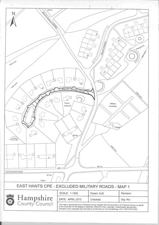
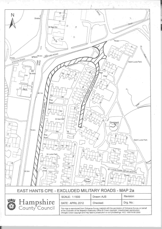
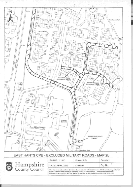
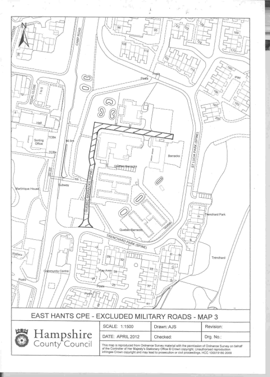
(d)the following roads in Bordon, in each case illustrated generally by the outer edge of a black line forming the boundary of a hatched area in a Map in Schedule 3—
(i)the Bolley Avenue spur from its junction with the Bolley Avenue spine at Ordnance Survey national grid reference point SU7872936259 to the end of the cul-de-sac at Ordnance Survey national grid reference point SU7859436184 as illustrated in Map 1 in Schedule 3;
(ii)the Saint Lucia Park spine from its junction with Lindford Road at Ordnance Survey national grid reference point SU8006036540 to its transition to the Trenchard Park spine at Ordnance Survey national grid reference point SU8003336044 as illustrated in Maps 2a and 2b in Schedule 3;
(iii)the Saint Lucia Park spur north from its junction with the spine at Ordnance Survey national grid reference point SU8005236504 to the end of the cul-de-sac at Ordnance Survey national grid reference point SU8002036369 as illustrated in Map 2a in Schedule 3;
(iv)the Saint Lucia Park spur south from its junction with the spine at Ordnance Survey national grid reference point SU8003636163 to the end of the cul-de-sac at Ordnance Survey national grid reference point SU8014736270 as illustrated in Map 2b in Schedule 3;
(v)the Saint Lucia Park sub spur east from its junction with the spur south at Ordnance Survey national grid reference point SU8006936210 to the end of the cul-de-sac at Ordnance Survey national grid reference point SU8013636170 as illustrated in Map 2b in Schedule 3;
(vi)the Saint Lucia Park sub spur west from its junction with the spur south at Ordnance Survey national grid reference point SU8005636198 to the end of the cul-de-sac at Ordnance Survey national grid reference point SU8000836220 as illustrated in Map 2b in Schedule 3;
(vii)the Quebec Barracks spine from its junction with the Trenchard Park spine at Ordnance Survey national grid reference point SU7990435990 to the end of the cul-de-sac at Ordnance Survey national grid reference point SU8001236105 as illustrated in Map 3 in Schedule 3;
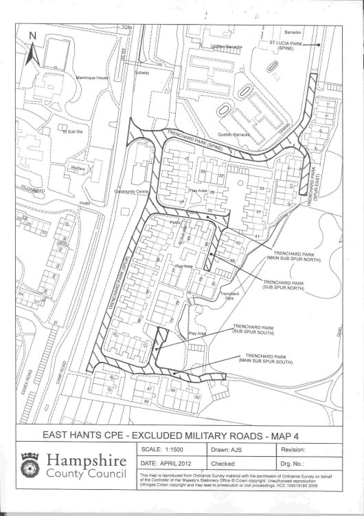
(viii)the Trenchard Park spine from its junction with the A325 Camp Road at Ordnance Survey national grid reference point SU7986535988 to its transition to the Saint Lucia Park spine at Ordnance Survey national grid reference point SU8003336044 as illustrated in Map 4 in Schedule 3;
(ix)the Trenchard Park spur from its junction with the spine at Ordnance Survey national grid reference point SU7989135982 to the end of the cul-de-sac at Ordnance Survey national grid reference point SU7982835768 as illustrated in Map 4 in Schedule 3;
(x)the Trenchard Park main sub spur south from its junction with the spur at Ordnance Survey national grid reference point SU7983735780 to the end of the cul-de-sac at Ordnance Survey national grid reference point SU7995035764 as illustrated in Map 4 in Schedule 3;
(xi)the subsidiary Trenchard Park sub spur south from its junction with the main sub spur south at Ordnance Survey national grid reference point SU7988435772 to the end of the cul-de-sac at Ordnance Survey national grid reference point SU7989035810 as illustrated in Map 4 in Schedule 3;
(xii)the Trenchard Park main sub spur north from its junction with the spur at Ordnance Survey national grid reference point SU7988735920 to the end of the cul-de-sac at Ordnance Survey national grid reference point SU7995535908 as illustrated in Map 4 in Schedule 3;
(xiii)the subsidiary Trenchard Park sub spur north from its junction with the main sub spur north at Ordnance Survey national grid reference point SU7994835904 to the end of the cul-de-sac at Ordnance Survey national grid reference point SU7993635860 as illustrated in Map 4 in Schedule 3;
(xiv)the Trenchard Park spur east from its junction with the spine at Ordnance Survey national grid reference point SU8001435980 to the end of the cul-de-sac at Ordnance Survey national grid reference point SU8002535932 as illustrated in Map 4 in Schedule 3;
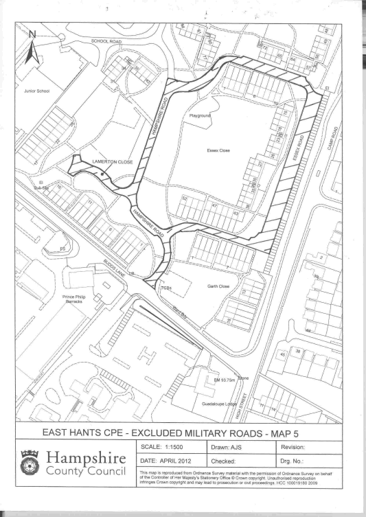
(xv)Hampshire Road from its junction with Budds Lane at Ordnance Survey national grid reference point SU7963635632 to its junction with Essex Road at Ordnance Survey national grid reference point SU7965635815 as illustrated in Map 5 in Schedule 3;
(xvi)Lamerton Close from its junction with Hampshire Road at Ordnance Survey national grid reference point SU7961935715 to the end of the cul-de-sac at Ordnance Survey national grid reference point SU7956635740 as illustrated in Map 5 in Schedule 3; and
(xvii)Essex Road from its northern junction with Hampshire Road at Ordnance Survey national grid reference point SU7965635815 to its southern junction with Hampshire Road at Ordnance Survey national grid reference point SU7965335677 as illustrated in Map 5 in Schedule 3.
Article 3(2)(b)
SCHEDULE 3Map 1
Map 2a
Map 2b
Map 3
Map 4
Map 5
Article 3(2)(c)
SCHEDULE 4The part of the area of The Northumberland County Council designated as a civil enforcement area for parking contraventions and as a special enforcement area
The whole of the area of The Northumberland County Council except—
(a)the A1 road from the boundary with The North Tyneside Metropolitan Borough Council at Seaton Burn interchange at Ordnance Survey national grid reference point NZ2325674531 to the border with Scotland at Ordnance Survey national grid reference point NT9739557054 including its slip roads;
(b)the A19 road from the boundary with The North Tyneside Metropolitan Borough Council immediately east of the Fisher Lane roundabout at Ordnance Survey national grid reference point NZ2369174610 to the further boundary with The North Tyneside Metropolitan Borough Council at Ordnance Survey national grid reference point NZ2821973424 including its slip roads;
(c)the A69 road from the boundary with The Cumbria County Council at Temon Bridge at Ordnance Survey national grid reference point NY6172963902 to the border with The Council of the City of Newcastle Upon Tyne at Ordnance Survey national grid reference point NZ1456667735 including its slip roads;
(d)the A189 road from the boundary with The North Tyneside Metropolitan Borough Council at Annitsford at Ordnance Survey national grid reference point NZ2714773648 to the northern side of Woodhorn Roundabout, Ashington, at Ordnance Survey national grid reference point NZ2945488283 including its slip roads;
(e)the U4023 road from a point immediately west of Alwinton village at Ordnance Survey national grid reference point NT9064606515 to the Makendon Cattle Grid at Ordnance Survey national grid reference point NT8030909338;
(f)the U5001 road from its junction with the A68 road at Ordnance Survey national grid reference point NY8270998219 to Redesdale Camp at Ordnance Survey national grid reference point NY8283198396;
(g)the U5003 road from a point north of its junction with the A68 road at Ordnance Survey national grid reference point NY8559596763 to Toft House at Ordnance Survey national grid reference point NY8636699639; and
(h)the U5004 road from a point north of its junction with the A696 road at Ordnance Survey national grid reference point NY8701796330 to Durtrees at Ordnance Survey national grid reference point NY8732597410.
Article 3(2)(d)
SCHEDULE 5The part of the area of The Solihull Metropolitan Borough Council designated as a civil enforcement area for parking contraventions and as a special enforcement area
The whole of the area of The Solihull Metropolitan Borough Council except—
(a)the entire length of the M6 Motorway within the borough, including its on and off slip roads; and
(b)the entire length of the M42 Motorway within the borough, including its on and off slip roads.
Article 4
SCHEDULE 6The part of the area of The Somerset County Council designated as a civil enforcement area for parking contraventions and as a special enforcement area
The whole of the areas of The Mendip District Council, The Sedgemoor District Council, The South Somerset District Council and The West Somerset District Council except—
(a)the M5 motorway from the boundary with The Taunton Deane Borough Council at Ordnance Survey national grid reference point ST2797428151 to the boundary with The North Somerset Council at Ordnance Survey national grid reference point ST3751554999, including its slip roads;
(b)the A303 road from the boundary with The East Devon District Council at Ordnance Survey national grid reference point ST2586810889 to the boundary with The North Dorset District Council at Ordnance Survey national grid reference point ST7558129941, including its slip roads; and
(c)Wood Road, Langport, from Ordnance Survey national grid reference point ST4242229528 to Ordnance Survey national grid reference point ST4176529841.
Options/Help
Print Options
PrintThe Whole Instrument
PrintThe Schedules only
Mae deddfwriaeth ar gael mewn fersiynau gwahanol:
Y Diweddaraf sydd Ar Gael (diwygiedig):Y fersiwn ddiweddaraf sydd ar gael o’r ddeddfwriaeth yn cynnwys newidiadau a wnaed gan ddeddfwriaeth ddilynol ac wedi eu gweithredu gan ein tîm golygyddol. Gellir gweld y newidiadau nad ydym wedi eu gweithredu i’r testun eto yn yr ardal ‘Newidiadau i Ddeddfwriaeth’.
Gwreiddiol (Fel y’i Deddfwyd neu y’i Gwnaed): Mae'r wreiddiol fersiwn y ddeddfwriaeth fel ag yr oedd pan gafodd ei deddfu neu eu gwneud. Ni wnaed unrhyw newidiadau i’r testun.
Memorandwm Esboniadol
Mae Memoranda Esboniadol yn nodi datganiad byr o ddiben Offeryn Statudol ac yn rhoi gwybodaeth am ei amcan polisi a goblygiadau polisi. Maent yn ceisio gwneud yr Offeryn Statudol yn hygyrch i ddarllenwyr nad oes ganddynt gymhwyster cyfreithiol, ac maent yn cyd-fynd ag unrhyw Offeryn Statudol neu Offeryn Statudol Drafft a gyflwynwyd ger bron y Senedd o Fehefin 2004 ymlaen.
Rhagor o Adnoddau
Gallwch wneud defnydd o ddogfennau atodol hanfodol a gwybodaeth ar gyfer yr eitem ddeddfwriaeth o’r tab hwn. Yn ddibynnol ar yr eitem ddeddfwriaeth sydd i’w gweld, gallai hyn gynnwys:
- y PDF print gwreiddiol y fel deddfwyd fersiwn a ddefnyddiwyd am y copi print
- rhestr o newidiadau a wnaed gan a/neu yn effeithio ar yr eitem hon o ddeddfwriaeth
- manylion rhoi grym a newid cyffredinol
- pob fformat o’r holl ddogfennau cysylltiedig
- slipiau cywiro
- dolenni i ddeddfwriaeth gysylltiedig ac adnoddau gwybodaeth eraill
Rhagor o Adnoddau
Defnyddiwch y ddewislen hon i agor dogfennau hanfodol sy’n cyd-fynd â’r ddeddfwriaeth a gwybodaeth am yr eitem hon o ddeddfwriaeth. Gan ddibynnu ar yr eitem o ddeddfwriaeth sy’n cael ei gweld gall hyn gynnwys:
- y PDF print gwreiddiol y fel gwnaed fersiwn a ddefnyddiwyd am y copi print
- slipiau cywiro
liciwch ‘Gweld Mwy’ neu ddewis ‘Rhagor o Adnoddau’ am wybodaeth ychwanegol gan gynnwys
- rhestr o newidiadau a wnaed gan a/neu yn effeithio ar yr eitem hon o ddeddfwriaeth
- manylion rhoi grym a newid cyffredinol
- pob fformat o’r holl ddogfennau cysylltiedig
- dolenni i ddeddfwriaeth gysylltiedig ac adnoddau gwybodaeth eraill
